
CoreLogic rolls out 2 new tools for using alternative data, assessing potential tornado damage
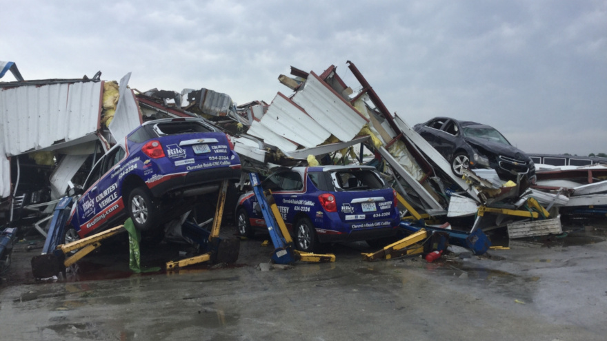
A tornado with winds approaching 160mph destroyed Riley Chevrolet in Jefferson, City, Mo., on May 22. Photo courtesy of the National Weather Service.
By subscribing, you agree to receive communications from Auto Remarketing and our partners in accordance with our Privacy Policy. We may share your information with select partners and sponsors who may contact you about their products and services. You may unsubscribe at any time.
IRVINE, Calif. –
Along with rolling out a tool that’s designed to deliver precise damage exposure data from a tornadic event within minutes, CoreLogic on Wednesday launched a solution aimed at leveraging the capability of alternative credit data.
The global property information, analytics and data-enabled solutions provider unveiled the new CoreLogic Teletrack platform, offering lenders and credit issuers what the company thinks is “superior access and greater insight” into alternative credit data through one of the industry’s largest alternative credit databases.
The new platform and solution combine upgraded services, data, products and an analytics engine to help users discover new market segments, make smarter risk decisions and grow their business throughout the credit lifecycle.
With the new platform, CoreLogic Teletrack customers can access traditional and alternative consumer credit data, and a suite of credit risk attributes and fraud prevention solutions, through the customer segmentation, customer acquisition, portfolio management, and collections and recovery phases.
“CoreLogic Teletrack has been a leader in the alternative credit data market for 30 years,” CoreLogic Teletrack senior leader Irina Kovach said in a news release. “The new CoreLogic Teletrack platform is built upon the same technology and trusted data that industry professionals have come depend on, but with new state-of-the-art enhancements such as an intuitive user interface, expanded data attributes and increased flexibility around how data is reported leveraging certain Metro 2® reporting fields.
“These benefits provide users with faster, more robust alternative credit data solutions,” Kovach continued.
Subscribe to Auto Remarketing to stay informed and stay ahead.
By subscribing, you agree to receive communications from Auto Remarketing and our partners in accordance with our Privacy Policy. We may share your information with select partners and sponsors who may contact you about their products and services. You may unsubscribe at any time.
Kovach mentioned CoreLogic Teletrack can provide information on more than 86 million thin-file, unbanked and under-banked consumers. With the ability to receive real-time updates, the database can accept new inquiries and a continuous stream of consumer loan performance data from businesses nationwide.
The new CoreLogic Teletrack platform is available now. For more information, visit this website.
CoreLogic launches tornado path maps solution
According to the National Weather Service, a tornado struck the capital of Missouri just before midnight on May 22, packing winds approaching 160mph and causing immense destruction in its path that included Riley Chevrolet, a large franchised dealership.
To help the industry respond to disasters like what recently happened in Jefferson City, Mo., CoreLogic announced its launch of Tornado Path Maps. The company claims it has the only solution available on the market that can deliver precise damage exposure data from a tornadic event within minutes — an analysis that can take up to two days to complete using other methods.
CoreLogic said insurers benefit from the ability to anticipate claims volume and adjuster deployment for streamlined claims processing, allowing policyholders to get the support they need faster than ever before.
Unique to CoreLogic, the company explained Tornado Path Maps can offer a data layer updated every 15 minutes following a tornado, displaying area probabilities (from 10% up to 90%) of tornadic damage. In addition to allowing insurance carriers to quickly calculate claims needs, this parcel-level exposure analysis means emergency responders, utility companies, transportation departments and others will be able to quickly determine resource allocation and deployment to begin offering on-the-ground support to the people and properties affected.
“Until now, understanding exposure from tornadoes has been a daunting challenge for most insurers, as typical ground-based observations and reporting are hampered due to infrastructure damage when a tornado moves through an area,” said Curtis McDonald, senior professional product management and meteorologist for CoreLogic Weather Verification Services. “These challenges can create frustrating policyholder experiences.
“Our goal with Tornado Path Map is to enable insurers to efficiently and accurately identify customers under duress immediately following tornadic storms, meaning they’re able to assist with communications and swift response to help their policyholders in need,” McDonald continued.
Tornado Path Maps is based on the proprietary CoreLogic Tornado Verification Model, which combines a novel comprehensive approach to using all available radar data, as well as public and social media reports, backed by the expertise of experienced meteorologists. The end result is the Tornado Verification Model that can provide 250-meter resolution with neighborhood-level detail across most of the United States.
Tornado Path Maps is part of the CoreLogic Severe Convective Storm suite of solutions, which also offers forensics on hail, wind and lightning.
For more information, visit the CoreLogic Tornado Path Maps page.